The Start
Our 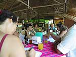 trip
began at the Panchan
Hotel in Palenque, Chiapas, Mexico. The hotel, a collection of one-
and two-story cabins scattered in its own bit of jungle, is located at
the entrance to the Palenque
Archaeological Zone. We all met the day before for the first time
and for orientation.
trip
began at the Panchan
Hotel in Palenque, Chiapas, Mexico. The hotel, a collection of one-
and two-story cabins scattered in its own bit of jungle, is located at
the entrance to the Palenque
Archaeological Zone. We all met the day before for the first time
and for orientation.
We met again the following morning at 6am. A VW Combi took us to the
put-in point by the road that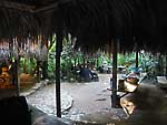 circles the Lacondon region along the border with Guatemala. It takes
about three hours to get there. En route, we stopped for breakfast at
the Rancho Escondido. It is a cattle ranch, but the owner, Willy, is interested
in tourism and has built a restaurant. He is planning cabins for the near
future. He was our liason for the trip and also joined us for the last
night and day on the river. His help was indispensible.
circles the Lacondon region along the border with Guatemala. It takes
about three hours to get there. En route, we stopped for breakfast at
the Rancho Escondido. It is a cattle ranch, but the owner, Willy, is interested
in tourism and has built a restaurant. He is planning cabins for the near
future. He was our liason for the trip and also joined us for the last
night and day on the river. His help was indispensible.
Breakfast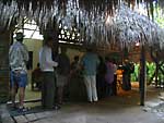 was a hearty affair of eggs Mexican style or with bits of ham, the ubiquitous
refried beans, tortillas and the very freshest fruit I can remember ever
having. Back on the road, the cleft in the mountains that is the canyon
of San Jose was pointed out to us in the distance. It was a preview of
things to come. We had still not seen the river. Palenque and the closer
part of the border road are some distance away. This began to feel more
and more like a "B" movie about an adventure in the African
jungle.
was a hearty affair of eggs Mexican style or with bits of ham, the ubiquitous
refried beans, tortillas and the very freshest fruit I can remember ever
having. Back on the road, the cleft in the mountains that is the canyon
of San Jose was pointed out to us in the distance. It was a preview of
things to come. We had still not seen the river. Palenque and the closer
part of the border road are some distance away. This began to feel more
and more like a "B" movie about an adventure in the African
jungle.
We passed some number of military checkpoints further along. This is, of course, an international border region but the area has other issues in addition. There is wide spread drug and people smuggling and, of course, the Zapatistas, a political group operating in the state and making international headlines. I had been warned about banditos on the highways and elsewhere. The US State Department reported attacks against tourists by the Zapatistas. To say the least, I was worried. The soldiers at the check points just waved us on. We were probably not what they were interested in.
We arrived at our put-in point, Frontera Corozal. It used to be called
Frontera Echevarría, in honor of the Mexican President who established
it. It is nothing more than a small collection of tin-roofed block houses
near the edge of the river. And there it was: the mighty and 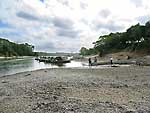 famous
Rio Usumacinta, the Sacred Monkey River. It was some 50 to 100 feet below
the town and the surrounding terrain. Wide and green and swift moving.
We had to pass through a checkpoint just at the foot of the path to the
edge of the river. It was military, but doubled also as immigration since
Mexico and Guatemala have a joint agreement to patrol their common border.
We submitted our passports, with our names and nationalities written down
for the official record.
famous
Rio Usumacinta, the Sacred Monkey River. It was some 50 to 100 feet below
the town and the surrounding terrain. Wide and green and swift moving.
We had to pass through a checkpoint just at the foot of the path to the
edge of the river. It was military, but doubled also as immigration since
Mexico and Guatemala have a joint agreement to patrol their common border.
We submitted our passports, with our names and nationalities written down
for the official record.
We made our way to the river's edge where Willy had pulled up his truck
with 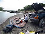 all our gear. He didn't even bother to stop for the Army and the soldiers
didn't seem too upset by it -- that typical languid Mexican approach to
life. We began preparing for our nine-day journey. The two rafts had to
be inflated. And also the rubber duckies - inflatable kayaks. We loaded
all the equipment we'd need for the next few days and put into the river.
Next stop later that afternoon: Yaxchilán,
one of the major archaeological sites in the region.
all our gear. He didn't even bother to stop for the Army and the soldiers
didn't seem too upset by it -- that typical languid Mexican approach to
life. We began preparing for our nine-day journey. The two rafts had to
be inflated. And also the rubber duckies - inflatable kayaks. We loaded
all the equipment we'd need for the next few days and put into the river.
Next stop later that afternoon: Yaxchilán,
one of the major archaeological sites in the region.